Logo U. Osnabrueck Institute of Computer ScienceKnowledge-Based Systems Research Group

Project Kurt3D


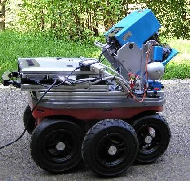
KURT3D is a mobile robot of type KURT2 that is equipped with a 3D laser scanner. Given the right control and sensor data processing software, it is generally able to build 3D models (data point clouds) of its working environment autonomously.

In the KURT3D project, we are dealing with the following topics:

  • 6D SPLAM. To build a map, the following three tasks must run in a permanent cycle: (1) Plan and goto the next scan pose; (2) Localize yourself in the current environment model; and (3) take a new scan and register it consistently with the previous model. We call this overall process SPLAM (Simultaneous Planning, Localization, and Mapping). At any time, the robot pose is to be determined in 6D, i.e., in coordinates x, y, z and with yaw, pitch, and roll angles – all wrt. a given coordinate system.

    We are working on the respective algorithms.

  • Sensor data interpretation. The sensor data of a 3D laser scanner yield a geometry model of the environment – no more and no less. We are working on algorithms for interpreting these geometry models, or parts of them, in terms of recognizing in them objects of known classes, e.g., chairs, tables, or walls.
  • Rescue. Our results are regularly used for participating with a KURT3D robot in international contests of the RoboCup Rescue Robot League.
Kurt3D Outdoor

There's also a picture gallery of Kurt3D available.

For further details, see the KBS publication list or the download page.


Valid HTML 4.0! Last changed: Mar 24, 2005